Primorska Planinarska Transverzala (PPT; translated as the Mountaineering Coastal Transversal, the Coastal Hiking Transversal or the Adriatic transversal) is an epic 10 day hike along the coastal mountains of Montenegro.
There hasn’t been a suitable known hiking guide for English speakers until now. Me and a few fellow hikers decided to create a new hiking guide about the PPT. The data comes from my hike of the PPT in autumn 2017 (for updates, check the comments below!). The foreword comes from Claire Leenen aka Reiske. The design done by Jan Kadera, and copyediting by Anna Walker. The guide contains relatively detailed maps, descriptions of each stage and stage profiles. It’s accessible as a PDF in 3 formats (2021 edit: the guide is getting out of date, please check the comments below for some very useful updates):
It’s available for donation via our honesty button below. It works exactly like an honesty box in the mountains where hikers honestly pay for things if they want them. So download the guide, read it, play with it and if you decide to use it, we trust you to send us a contribution via this button:
You choose your price for what you think the guide is worth. This system is in line with our philosophies and world view.
Don’t forget to use the guide properly though: don’t rely on it blindly. We did our best to make it as accurate as possible but we’re just people (just for now though, we’re working towards our enlightenment). People make mistakes. But, above all, nature and trails change quickly so what is a pine tree and stream today, could be a pine tree and desert tomorrow!
If you want to know more about the trail, keep reading, otherwise enjoy the guide!
Trail overview
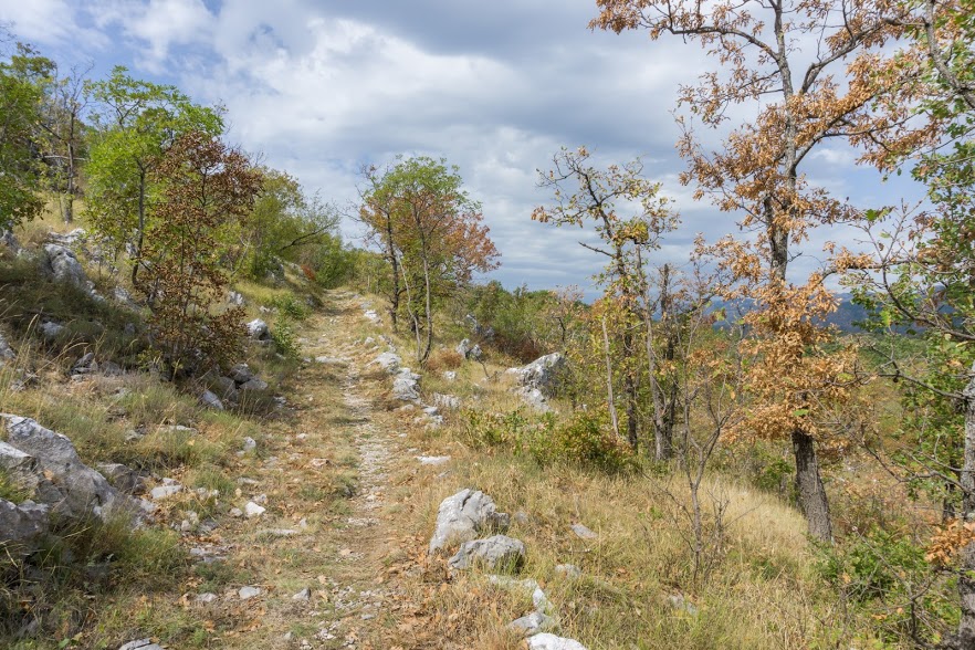
The PPT is one of 2 long distance hikes in Montenegro (the other one is Crnogorska Transverzala, or simply CT1). The PPT was opened in 2006 as a result of a lot of effort on the part of local hiking clubs. It connects three important mountain massifs of the country: Rumija, Lovćen and Orjen. It roughly stretches from the Albanian to the Croatian border. However, though the name implies there might be a lot of beach walking involved, the opposite is the true. You do see a lot of the seacoast though and it is stunning.
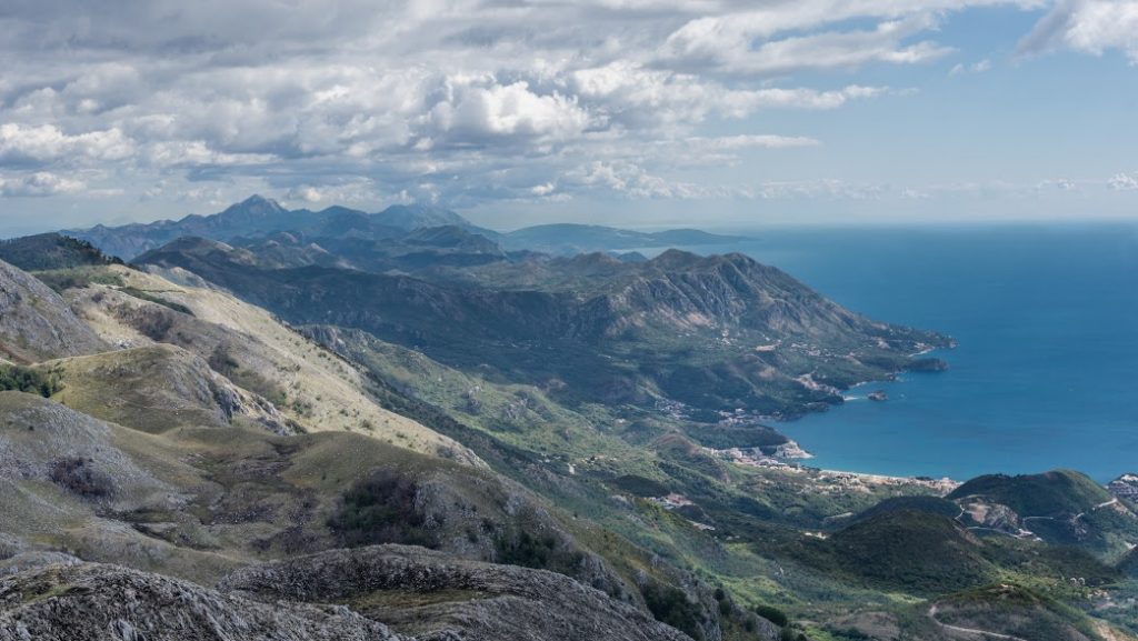
Yup, you’ll have a lot of views like that
It’s about 180 km long and it can be walked in either direction. Each direction has advantages and disadvantages. For example:
If you go NW bound (from Bar to Herceg Novi):
- Disadvantage: You won’t find many signposts pointing your direction as they’re designed for SE hiking, so the signposts usually point where you’re coming from 🙁
- Advantage: You will not have to climb up to Subra and down to its amphitheater with a big load of food for a few days as it will be at the end of your hike. I wouldn’t recommend this climb with the fully loaded pack. It’s quite a decent climb up even without a pack and the way down could be particularly difficult. 🙂
If you go SE bound (from Herceg Novi to Bar):
- Advantage: The signs will be pointing your directions 🙂
- Disadvantage: You’ll hike the first section over Subra amphitheater with a fully loaded backpack 🙁
Getting in & out
There are heaps of buses to both Herceg Novi and Bar. To Bar there is even a train connection from Podgorica. At Herceg Novi, the markings start directly at the bus station which is really nice. Check Balkanviator.com for bus schedules, or zcg-prevoz.me for train schedules.
Navigation
Finding markings is either very easy or very hard. In some parts the markings are as shiny as a kid’s bum, while in other parts the trail is heavily overgrown and requires constant bushwhacking. Therefore, good maps and navigation skills or GPS are essential.
You can download our GPX files here.
Food & water
There are a few restaurants and a café on the way. But, they don’t have any groceries for sale so I wouldn’t recommend relying on them. If you’re thru-hiking, you have to carry all the food you’ll need on you. Roughly in the middle of the trail there is a small village, Brajići, with a restaurant and a bus stop where you can take a bus down to the coastal town of Budva to resupply. I’d recommend that, it’ll make your life easier and lighter. At different points on the trail you’ll also cross a main road a few times where you could potentially hitch to a nearby town to get some food but it could be time consuming.
Water could be an issue. There are a lot of water cisterns (wells) on the way but their water quality varies greatly. It’s not uncommon to find a dead wild pig or a deer floating inside. Some of the water cisterns are very nice with a solid cover, but you’ll need a bucket with a rope or similar system to fetch the water. Good, fresh water sources are scarce. I managed to drink from fresh water sources or nice water cisterns all the time, but I had to plan carefully every day and ask locals for water twice. I carried 1,5 to 4 litres of water on me and it was enough. If you hike in summer, I’d recommend carrying even more in some sections because in 30 degree temperatures, dehydration occurs quickly.
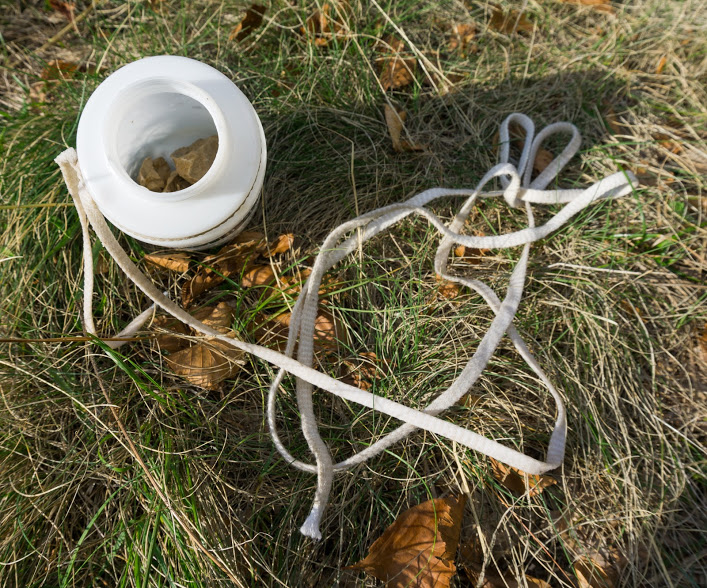
My fetching system: cycling water bottle I found in a trench which I filled with stones and tide with a spare leash
When to hike
I hiked the trail at the end of September and I’d say it was the best time of the year. The heat during summer can be unbearable and I’d rather get a bit wet during early autumn or late spring than puff up the steep hills in 30 degree temperatures. October could be tricky because the mountainous parts can be snowy already. Actually, two weeks after I finished the hike, there was a snowstorm over the tops bringing 30 cm of white icing to the mountain tops. It rarely happens earlier but you should be prepared for any kind of weather.
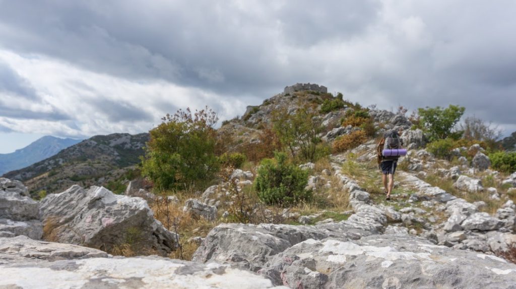
Me & the fort Sveti Andrija
Gear
Since some parts are overgrown, good pants and long sleeve shirts come in handy to protect your skin. You can get by without it as I did, but be ready for some blood and dirt. Thanks to the bora, wind could be an issue too so a wind jacket is a good idea. The Adriatic Alps can get very, very hot in the summer months so I’ve found proper sun protection to be essential.
My impression & more photos
It’s an awesome trail. Seriously, one of the best trails I’ve done. The Adriatic Alps are amazingly beautiful, the Adriatic sea is stunning at any time of year and the trail itself is challenging but enjoyable. Yes, there are some parts where you’ll be swearing over innocent nettles, spiky junipers and house ruins blocking the trail. But these experiences will be more than made up for by magnificent views over the coast, sunrises over the white mountains and incredibly well made mountain highways looking like they were made for hiking. You get to walk through abandoned villages made out of the drywall technique, you’ll see lots of goats and shepherds resting under oak trees and you’ll walk many miles over mountain roads and forts built by the Austrian-Hungarian Empire. Throughout the whole trail I met only 4 hikers during 8 days of hiking, all of them in the Lovćen National Park. Finally, it is also the most challenging trail I’ve done, mostly because of the lack of water and big elevation changes. I wouldn’t recommend it to a beginner hiker but if you know a bit about mountains, this is the hike for you! By the way, you can find more of my pictures from the trail here.
See you out there!

Thank you so much for your post. My intention was to do the trail this June 2023. Your description was helpful in every aspect. And yet, the trail was so overgrown for many kilometres after Čorotaj (some kilometres behind Rumija) that it was almost impossible to get through. Also be aware, that there are no more signs if you follow this route. Since I did not have enough time, I decided to get out of the trail and do smaller sections of it. Don’t forget to take a machete with you. NO JOKE!
That’s a shame that it was overgrown! Thank for the report
Just hiked the PPT from Sutomore to Donji Orahovac. All around beautiful route, but parts of the trail are completely overgrown, and even though there are a lot of markings, it can be really hard to find your way (read: you make your own way because you can’t actually see any path whatshowever). Just a little warning if you’re used to the Austrian mountains for example. Spiders, spiky plants, snakes (and a ferret if ur lucky) are not uncommon. The part trough Lovcen was well managed and fairly easy.
Good luck have fun 🙂
Oh wow that’s good to know, thanks Tom for reporting this
Hi! Thank you for the guide. We’ve taken some info into consideration which was useful.
We were hiking from Ivanova korita to Bar (May 2023). And I’d like to share a few tips as well.
1) Bad news: Don’t rely on draw-well sources – we’ve taken out a died bird fm there. And most of them looked unfresh.
2) Good news: at least one source of water will be running water (spring/river) on every stage.
3) Beware of wild animals. We’ve heard possibly roarings of a bear or deer near Tvrdava Sutorman. Very beautiful place to overnight, but after scaring sounds nearby we decided to pack our tent and things back and go down the hill.
Mostly wild animals are trying to avoid people, but sometimes not. If an animal does not react to your noise, try not to panic – a headlight directed to the animal usually works well.
Thank you for the update. The water resources are definitely challenging on this trail. My intention was only to mark where possible water could be taken from, but the situation out there is very dynamic. Some wells dry out, and others are polluted… Also, thank you for the warning about wild animals!
AMAZING CAMPING SPOT STAGE 9 BEGGINING:
There is an English couple that live in a cabin just 800m of the walking trail, the mountain hut on Orjen is very often closed so this was a great place to find on route and we even turned up when they had a BBQ and Beers so they put out extra for us. lovely fresh cold outdoor shower down the side of the house, the water is from water cisterns they say its not drinking water but they drink it and we did too and it was fine. great spot really friendly and worth the little detour plus they know lots about the history of the area.
TO FIND:
turn to map on page 46. coming in from the East you have a cistern symbol then a ruins symbol and then a sign post symbol, at the cross roads where the signpost symbol is you want to follow the wooden signpost they have put up pointing towards camping heading uphill onto a short steep concrete drive then follow the gravel track for 800m and your there. if they aren’t in just camp on the bottom field where the sign on the big tree is and pop some money under their door.
ENJOY very refreshing welcome break!
Crkvice – Vrbanj section : At the first sign post (at the end of the tarmac road), you’ll find a makeshift ‘camping and shower for €5pppn’ sign pointing 800m up the hill and off the trail to the right. A green roofed cabin have a large field for camping, outdoor shower and tap. Free to use outdoor tap and shower if nobody is at home. Water is from a covered well.
Hi! Can I ask which part of the trail is the part you need to hold on to the ropes to get around he boulder? Its on the photo DSC02155.jpg in your gallery 🙂
Thank you in advance!
Triin
That will be Subra! The first / Last day. It’s the first mountain when walking from Herceg Novi
Hi, Michal!
Thanks for the PPT guide – you are doing great job in helping out people like me to get to know new places.
I’m going to walk PPT section (Step 6 to step 9/10) this May.
And I need to understand logistics. I am going to fly to Podgorica. So far is clear. Then I need to get to the start of step 6.
So I have two questions as follows:
1) How can I get to Ivanova Korita? The guide says taxi. But from which town?
2) If I finish my trek in Vrbanj (not sure if I want to climb Subra’s amphitheater), how do I get down to Herceg Novi? Again, the guide says taxi. But I have no idea if it is possible to call taxi from Herceg Novi (or other towns)?
I’d hugely appreciate your input on that.
Thanks in advance and have a great day!
Boris,
Riga, Latvia.
Hi Boris, please note that the guide may be getting old now… There may be some buses but taxi is always the most convenient, reasonably cheap option. I personally didn’t use taxis but there are always taxi drivers at bus stations asking if you want a ride. It’s a good idea to negotiate the price before you jump in. I’m sure that you’ll manage to find a lot of taxis at a local bus stations (eg. Herceg Novi), get their number and call them from Vrbanj 🙂 If you can’t go to Herceg Novi, you can always get to Vrbanj and ask around, all locals always know about local taxis and accomodation options – when they see a hiker, they often ask you before you ask them!
Hi there!
Thanks for this really helpful guide (which is more or less the only reliable source of information about that trail…:D).
We just finished it and I wanted to add that there are no “not well marked” parts anymore. It seems like they changed the part of Stage 2 where you found no markings/hardly any markings and overgrown trails completely so that the path is still overgrown but easy to follow. Apart from that all relevant things are still the same as they used to be when you wrote the guide. I assume they worked on some parts of the trail and recently most of the markings got some new paint! 🙂 On the other hand, half of the trail signs were not readable anymore, I guess there was too much sun. The ones you could read were pointing in all kind of direction but not the one they were supposed to, don’t rely on them! GPS was much of a help!
For those who ask about taking a dog: our little Foxterrier was with us on all parts on the trail. Definitely make sure to have some paw-protection when your dog is not used to walking on very sharp rocks the whole day, apart from that and the heat during noon-time she was fine. It’s definetly doable with a dog if the dog is used to hiking in rough terrain and you are able to carry extra water and food.
Talking about water: most cisterns still had water and we never really run into trouble with finding enough even though it is mid of September already.
We enjoyed the trip so much, thank you again for your effort to make this guide!
Verena, Niek and Nika the Foxterrier
Hi Verena, what a useful info, thanks! I’ve added into my article that it’s a good idea to check the comments. Hiking movement in Montenegro is growing fast and it would’t surprise me if locals would put energy and resources into such an amazing trail. I’m hoping to get back one day and release an updated version – for now it’s a good idea to use my guide together with experiences shared by other hikers in the comments.
Happy hiking!
Ahoj. Na jar by sme chceli absolvovať časť okolo Kotorského zálivu. Mal by som otázku k etape číslo 7 Velji Zalazi – Tvrdava Sveti Andrija. Píšeš v sprievodovi o ťažkom úseku a ja budem mať so sebou psa. Myslíš že ten úsek bude pre psa priechodný? Na pohyb na horách a skalách je zvyknutý, žijeme totiž vo Vysokých Tatrách, ale predsa len lezecké úseky nezvládne. Za radu ďakujem Martin
Hi. In the spring, we would like to take part around the Bay of Kotor. I have a question about stage number 7 Velji Zalazi – Tvrdava Sveti Andrija. You write in the parade of a difficult section and I will have a dog with me. Do you think the section will be passable for the dog? It is used to move on mountains and rocks, because we live in the High Tatras, but it is not possible to climb climbing sections. Thank you Martin for your advice
Ahoj! Nahoru a dolu se dostanete po pesine, to muze byt trochu zarostle. Ten usek samotny, co si pamatuju, patri k tem tezsim usekum. Nicmene pokud je Tvuj pes zvykly na chozeni v horach a Ty na Vysoke Tatry, nebudete mit problem. Jde jen proste o to ze mozna nechate na mistnich kroviskach par chlupu 🙂
Thanks for this great guide! Thanks to this, I will be able to prepare well for the passage of the route in the FKT format.
https://fastestknowntime.com/fkt/oleg-chernov-primorska-planinarska-transverzala-montenegro-2019-10-22
It was a wonderful 83 hours of mountain trails!
Sources of water, unfortunately, are not all relevant.
The description of my passage can be read at the link:
https://mountain-race.ru/news/primorska-planinarska-transverzala-v-cernogorii-ili-83-casa-kamnej
and video:
https://www.youtube.com/watch?v=r7QQBlwbIrM&feature=youtu.be
Congratulations Oleg to FKT, that’s really fantastic.
Yes, sources of water are tricky as I wrote in my article and as other folks pointed out in the comments. I can only advice everyone once again to take heaps of water and be prepared that water sources pointed out in the guide might not be there anymore or might be contaminated
I made a map of water sources, you can download it in google docks
https://drive.google.com/file/d/1D1Tu4bjFtBq0qlrhTFnF-o-9LqHpwNQu/view
Water 1 – good, easily accessible sources of clean running water
Water 2 – suitable for drinking water without boiling, but in most cases requiring filtration, access can be complicated by the depth of the well and the lack of devices for water intake
Water 3 – overgrown dirty ponds with stagnant water
Water? – theoretically existing, but not discovered by me sources
Do you know if it is possible to hike further south along the Rumija range down towards Vladimir on the road from Shkoder to Ulcinj? There is a new line of wine turbines along the ridge and it looks like they have built a rough road just below the summit.
Hi Tim, I’m not sure to be honest. I tried to hike down from Rumija to Loska (1353m) and that’s possible more or less. Parts of the trail were overgrown and the shrubs so prickly that it wasn’t a pleasant experience. I’d suggest to try look for GPX files if there are any
Thanks for your great efforts to create a Guide for the trail, it is really useful and has a lot of info. Anyway, I want to add a few points after completing Stage 1..6 in mid September, 2019:
1) Stage 1 – There is no difficult segment actually – it is steep, but nothing else – I didn’t use my hands, path is clear, plus it is logical to leave your big backpack somewhere in the bushes and go up and down with just bottle of water and photo camera
2) Stage 2 – Trail is really missing from the cistern in the bottom (at 10 km), before it is rather good visible
3) Stage 2 – Small steam 1.2 km before the end of stage – actually seasonal – there were no water in mid September in spite of heavy rain a few days earlier
4) Stage 5 – There is a spring near the start of section (in form of tap near the road) – it is marked on OSM
5) Overall, for sections that I passed – 1..6 – information about water is very misleading. I mean there is no point in marking all these broken cisterns and muddy puddles for cattle – I would better carry additional 1-2 liters of water or be thirsty for half a day, then risk my health drinking from cistern with dead animals or puddles full of shit. Delete all this bad water sources, so people will expect water only from safe sources – taps and steams – and will plan accordingly – take more water or may be skip the trail completely.
6) I would recommend to do altitude diagram with same vertical scale across stages – it will give instant impression of how steep or flat the section is – right now they looks the same because diagrams have the same height. Not the big problem, but anyway.
Hi Sergey, thanks for the message. I’m sure this will be helpful for other hikers!
Hi! I tried it in early June this year, so hot weather! I walked up to the peak Subra, looked around, and I found myself thinking “what a boring landscape”. So I decided to went back to Herceg. I don’t like mountains like this. I went some similar trails before in Crete, Corfu and even Croatia, which i didn’t like too. Too much rocks, little greenery, imho.
Well, it’s Balkans, you don’t find there bush like in New Zealand or waterfalls like in Iceland. I wrote a few times that summer is not the best time to go as it can get unbeliavably hot 🙂
Hi Michal,many thanks to you and the other authors for this helpful guide. We just finished the PPT for the most part (Bar to Perast). Unfortunately, the bad weather, it rained all day for 6 days, took a toll on us and we stopped in Perast. With rainy weather the stony pathways are very slippery (I expect due to the white and red fungus on them?). The signpost were overgrown or hardly to spot on significant parts of the trek. Similar to hikers before us, We tried to build as much stone signpost as possible. The GPX track on outdooractive.com was a big helper. It often showed a better path than your GPXs where you indicated “difficult” bit in your guide. Nonetheless, it is beautiful country/hike in deed.
Hi Jean! It’s a shame to hear that you had so much rain. Crossing some of the parts when they’re we must have been pretty awful 🙁 Thank you so much for building the stone cairns, that’s really great! That’s what helps to keep the trail alive. Cool that you found a better GPX. I guess I should go back then soon and re-check my GPX and make them better 🙂 Have a good day and thanks again for letting us know about your experience
I am planning to visit Montenegro in late March/early April 2019 to walk the Primorska Planinarska Transverzala (PPT) or Mountaineering Coastal Transversal.
I believe that the Mountaineering Association of Montenegro (PSCG) has published an English language guide to the PPT. How can I obtain a copy of the most up to date edition of the guide?
Has the Subra Mountaineering Club in Herceg Novi also published an English language guide to the PPT or is their guide the same as the PSCG guide?
Does the guide describe the PPT route from north to south (Herceg Novi to Bar) or from south to north (Bar to Herceg Novi)?
Could you also advise me on what are the best most up to date maps to use to walk the PPT. Where can I obtain these maps and what scale 1:25,000 or 1:50,000 are they?
As for the weather, will the PPT be free of snow in late March/early April or is there likely to be snow in the higher mountainous parts of the PPT at that time of year?
Lastly, how well signposted is the PPT for its total length of 182 kilometres?
Thank you for your help in answering my questions.
Hi Alastair.
I’m not sure of the PSCG guide, they didn’t answer to any of the e-mails I sent them.
I’m not aware of any more recent guide than mine that is linked above. It describes the hike from south to north, just check the links on top of this page.
Up to date maps might be for sale in local mountaineering clubs but I didn’t find any.
I think that the end of March / April there will still be snow on the mountain tops. However, you should be able to avoid it. Eg. you don’t have to climb up to the top of Mt Rumija and you can go around Subra if it’s still snowy.
The signposting is excellent at some parts, non existent at the others.
If I was you, I’d start with my hiking guide and take it from there. Some of the questions you’re asking are answered there.
I hope that helps 🙂
Hi Michal! I had a gpx track that my friend gave to me and it was reliable enough. I also used a handbook for PPT which contaialns a lot of useful information. I haven’t met any hikers on the route except several tourists at Lovcen and few people in the villages. There is a very nice report written with pictures from start till the end of this adventure, published on my facebook page “Ultimate Hike”. However, the report is written in my native language- Serbian, and i am considering to translate to English as well. I am also planning to complete CT, maybe this autumn or spring next year. Also, PPT in May again :). Please let me know through my page when you come to Balkans, we can do some hikes together. Best from Alex
Very good! I’d like to hike the CT next year in the spring but we’ll see – too many hikes in the world you know! Thank you for stopping by again, it’s great to hear from someone who hiked it too 🙂
Hi Michael, i completed the trail yesterday and it was very hard since i did it in less than 6 days. You were right, it was bone dry and very hot. However, there is a lot berries on the way in September which can reduce the need for water. Also mushrooms which i eat raw. My plan was to be as light as possible and to be fast. At the end, i am very satisfied and the words cannot explain the beauty of trail and amazing views. This is one of the long distance trails i enjoyed the most. Looking forward to winter time and visiting again the Subra peak and Orjen region. Best from Alex
Hi Aleksandar! Great to see you came back here to let us know about your experience. If you’re willing to share the story of your hike or some pictures, please, let me know and I’ll be happy to publish it here. Water is surely an issue. When I hiked the PPT in 2017, I had GPS coordinates from Reiske who did the hike in 2016. The coordinates included water resources but I found out that only about 70 % of them were actually there. Very tricky, you never know up there. I agree that it’s very hard to express the beauty of the trail. Did you meet any other hikers? I met only a few in Lovcen National Park but that was it. I feel like the PPT is a European hidden hiking diamond 🙂 I’m hoping to get back there next spring to hike CT1
Next year I plan to go this route at the end of April (21.IV-2.V). Will there still be snow in the higher parts of the mountains at this time? And which map of the region do you recommend to buy?
Hi! It’s hard to say if there’ll be any snow. I was there in the end of September / beginning of October and there was a snowstorm just a few days after I finished. It brought about 20 cm of snow. If there will be snow, I think it’ll be mostly in the highest parts which are Mt Rumija, Mt Lovcen & Mt Orjen. The good news is that you don’t have to climb these tops to continue on the trail, all of them are side trails. If I was you, I wouldn’t expect snow but I’d be ready for it, just in case. April should be beautiful there – probably a bit wet but beautiful!
Hi guys, i am planning to do the PPT at the beginning of Sept. So if anyone is willing to join me, please let me know. It would be nice to have a company. Alex
Hi Aleksandar, that’s great to hear you’re gonna hike it. I’d love to join you, but I’m planning on doing other hike in September (possibly in Montenegro too though!). It’s been very dry year so make sure you’ll carry enough water, I reckon that the mountains will be bone dry this year. I’m sure you’ll love it! Let me know here how was it when you finish 🙂
Hey Michal, I love your lines, magic and very inspiring !
As being a professional hiking guide in Montenegro, quite a lot focused on the Coastal mountains, 5 years ago started a volunteering project together with my good friend Dare. The aim is to protect trails from overgrowth as well as to promote the hiking opportunities in Montenegro. Promoting the outdoors lifestyle to our local folks is an important focus too.
One of results from our Proljećni Kamp (the Spring Camp) is a nice short film about this happening and the Coastal Transversal. Anyone interested to feel it’s atmosphere can check at:
https://www.youtube.com/watch?v=sx44n3cQjWc
The Spring camp volunteering program can be found at (usualy updated from March each year, hopefully in 2019 we make it earlier)
http://www.springcamp.me
Dare and myself would be happy to see you or any of your friends joining the Spring Camp! And believe me, May is the most magic period to wake up and walk the highlands and summits above the Adriatic!
Welcome & Sunny Regards
from Montenegro
Hi Vlatko!
Thanks for the comment. I’ve checked the video and it looks lovely. I’d actually be keen to come next year. I live in Canada now but in autumn I should move back to Europe. I actually think I’ll be in Montenegro in autumn again. Seeing the country in the spring sounds fantastic though, I’d love that!
I’ll keep an eye on the camp website for the next year camp 🙂
Greetings from rainy Canada,
Michal
Great piece of work. Just come back from a short trip to the coast of Montenegro and loved it. Climbed up Rumija and Velji Kosmac to get a taster and was very impressed. The views are amazing. Will definitely be coming back to do more.
Hi Molineux! I’m really glad you liked our guide and the hike too! Yes, the views are really amazing. At some point you can see all the coast from Albania to Croatia which is fantastic. If you’re into a bit of adventure, try the hike over Subra (stage 10 in our guide). Stay safe!
PS: I think we’ll be back this autumn again, I can’t wait!