| Walk Facts | Good book about tramping in New Zealand | |
|---|---|---|
| Distance | 23 km |  |
| Ascent | ~700 m | |
| Estimated time | 8 hours | |
| Hiked on | 22-23rd September 2019 | |
| Map & GPX files | See the online map below (with GPX download) Open the track at NZ Topo Maps |
More books about tramping in New Zealand |
Anna was waiting for me in the car with our backpacks ready for the weekend adventure. It was Saturday 5pm and I just finished my last shift of the week. I jumped into the car and changed into my tramping baggy clothes while Anna was driving south-west towards Lake Clearwater in Hakatere Conservation Area. I’ve been in the area before but it’s just such an epic place that I’ll happily keep coming back. Though, it’s a shame that it’s been deforested. What an amazing forest could have been there today!
We arrived at the car park by Lake Clearwater when it was pitch dark. We started to hike towards the lake with headlamps on. Soon we entered the fog which was so thick that we couldn’t see further than a few meters ahead. We didn’t see the point in hiking any further and we pitched our tent right where we were standing. Falling asleep not knowing how it actually looks like around is always quite adventurous and makes the following morning very exciting.
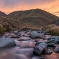
We woke up with the first light and unzipped the tent which was covered with a thick layer of ice on both the inner and the outer side. It made a crunchy sound and as ice was falling down on our sleeping bags, we peaked out to see what was around us. It turned out that we were right on the side of the fogy lake filled with swimming ducks on the background of snowy mountain tops. Heaven.
Anna and the mountains
It was pretty chilly, I reckon at least minus 5. We made ourselves a hot chocolate, maybe two actually, and packed up. We hiked along the southern side of the lake and soon joined with Te Araroa Trail.
Mt Potts
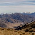
We followed it west until we reached the eastern side of a deep canyon with Potts River winding at the bottom. That canyon is quite epic actually, very rugged and scenic.
Potts River canyon
We turned north and after about 2 hours of following Mystery Lake Track we reached Mystery Lake. It’s such a pretty lake, quite unexpected in such a dry area and in a steep slope. We skinny dipped, ate lunch and continued along Mystery Lake Track.
Lake Mystery
After joining with Te Araroa Trail again, we turned south towards Lake Clearwater. This part is, again, very dry and exposed to elements, especially the sun and the wind. Therefore, good sun protection is highly recommended. We finished the loop when the sun was already quite low.
Lake Clearwater
It was very scenic trip. I’ll make sure to come here more often in the winter when the mountains are covered in snow. It just adds a bit of magical vibes to the area.
Map
Max elevation: 1119 m
Min elevation: 674 m

Be the first to comment on "From Lake Clearwater to Mystery Lake in Hakatere Conservation Area, Canterbury"